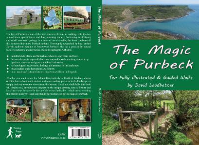
 | BOOK DETAILS |
Ten fully illustrated and guided walks on the Isle of Purbeck.
The Isle of Purbeck is one of the best
places in Britain for walking, with its own microclimate, special fauna and
flora, stunning scenery, world-renowned geology and ancient history. In a
series of circular walks, this book combines all the elements that make Purbeck
unique. Thoroughly researched by local author David Leadbetter (the author of Paranormal Purbeck) who has a passion
for natural history, prehistory and mysteries, the book highlights Purbeck’s:
- birds, plants and butterflies, where to spot them and how;
- historical
aspects, especially barrows, unusual burials, standing stones, strip lynchets,
churches and graves, and local industries;
- archaeological excavations, findings and markers in the landscape;
- place
names, their derivations and history;
- man-made
and natural features, mysterious folklore and legends.
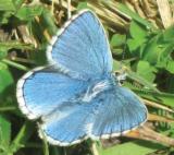 | Whether you want
to see the Adonis Blue butterfly or Dartford Warbler, admire orchids, learn
about man’s ancient and more modern presence in the landscape, or simply soak
up awesome views from the Jurassic Coast and chalk hills, this book will
inspire you. Introductory chapters on the unique geology, natural history and local history set the scene for the carefully researched walks – which are so revealing that visitors and even locals can’t fail to be mesmerised by the magic of Purbeck. |
PREFACE
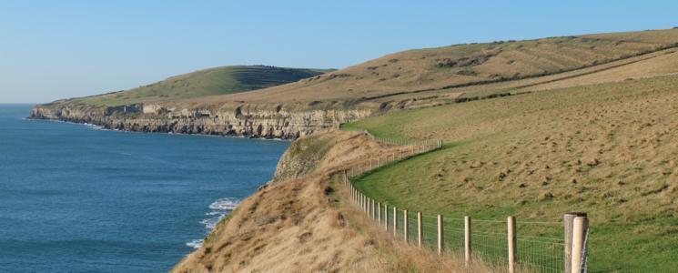
The Isle of Purbeck has stunning, varied
scenery within a small geographical area, as well as a wide range of fauna and
flora and rich local history. The aim of this book is to introduce some of the
features that make the area such a special place, hopefully inspiring the
walker to experience some of the ‘magic’ of Purbeck. The walks vary in length
and cover a variety of terrain. Maps are provided for each walk, though an
Ordnance Survey map is also recommended. Many of the walks can be adapted to
suit the individual, who may wish to do a section of the route or even go
further. All can be accessed by public transport, though Walk 7 is best done
from the car park north-east of Kimmeridge.
Of
interest to local people as well as visitors, while some walks may be familiar,
the unique combination of features described is likely to introduce the
reader/walker to new aspects and raise awareness of how special Purbeck is. As
well as geological features there are details of where to find some of
Purbeck’s notable birds, plants and butterflies – the author has focused on
these groups as they tend to be the most obvious, though other taxa are also
described, and there are identification guides listed in the References.
Descriptions
of historical and archaeological features are given, with special reference to
barrows, unusual burials, standing stones, strip lynchets and churches. Mention
is made of archaeological excavations and findings and also the derivation of
place names. A special feature of the book is the introductory chapters on
local geology, natural history and local history; with regard to the latter,
the author has concentrated on the prehistoric era and Roman Conquest as these
are less well known than later periods.
Whatever
your interests, the author’s message is: enjoy walking in Purbeck and discover
the magic for yourself.
CONTENTS
Map of the area
Geology and Natural History
Purbeck Through History
Walk 1-Ulwell
Gap, Ballard Down, Old Harry and Studland
Walk 2-Studland
Village to Agglestone Rock, Studland Heath and Beach
Walk 3-Ulwell
to Ailwood Down, King’s Wood and Rempstone Stone Circle
Walk 4-Langton
Matravers to Dancing Ledge, St Aldhelm’s Head and Worth Matravers
Walk 5-Kingston
to Corfe Common, Hill Bottom and Chapman’s Pool
Walk 6-Kingston
to Kimmeridge and Houns-tout
Walk 7-Kimmeridge
to Tyneham and Grange Arch
Walk 8-Corfe
Castle to Creech Barrow Hill and Stonehill Down, then
Knowle Hill and West Hill
Walk 9-Corfe
Castle to Challow Hill, Sharford Bridge and Corfe Charity Meadows
Walk 10-Wareham
to Stoborough, Creech Bottom, Soldiers Road and Ridge
EXTRACT FROM THE BOOK - Walk 8
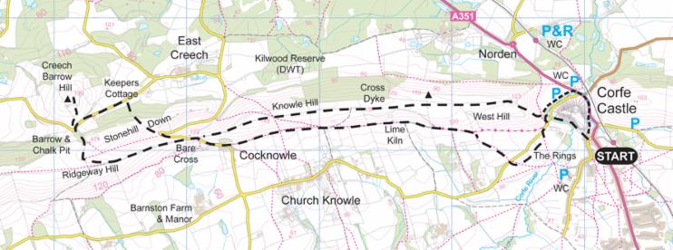
From the village square walk towards Corfe Castle Tea Rooms near the castle entrance and take Ollie Vyes Lane to the left round the south side of the castle. There is a good view of the crumbling walls built of Purbeck Stone; the castle was deliberately blown up in the Civil War on the orders of Parliament following siege when it was defended by Lady Bankes. Excavations in the West Bailey showed traces of an early building, which may have been the royal house at the time of King Edward the Martyr’s murder in 978; pottery sherds from the 2nd century have also been found here.
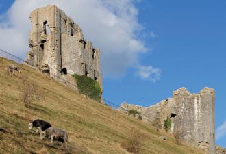 Crumbling Corfe Castle. | Ravens and birds of
prey frequently fly over the castle and in summer you may see the small Lulworth
Skipper butterfly on southern slopes close to the path, as its food plant, Tor-grass, can be abundant when grazing
has not taken place. This butterfly is mainly confined to south Dorset and can
occur in large numbers in some years. Common Rockrose is frequent here
in late spring/early summer, while later flowers of Burnet Saxifrage and
Marjoram adorn the slopes, with some Common Calamint. Wicken Stream (part of Corfe River) is on the left. Saxon ‘Wicunstreames’ means ‘stream of the wicks’, with ‘wics’ probably meaning ‘dairy farm’. At the end of the path, cross the road just right of the stone bridge and walk over the wooden bridge. To the right is the former site of West Mill, a water mill built in the 18th century, though an earlier mill is shown on Ralph Tresswell’s map of 1586. |

Geophysical survey has shown that ‘The Rings’ were probably built on top of a Saxon field system
Leave The Rings at a stile in the corner by the hedge, heading west. Cross the road again and follow the sign to Knowle Hill across a field. Exit the field onto a bridleway, turning left along the bottom of West Hill. Part of the track is festooned with Old Man’s Beard and blackberries in autumn and migrant birds may often be feeding in the bushes. Stonechats are resident for much of the year. Look out too for butterflies, including Marbled Whites, Skippers and Blues in open clearings.
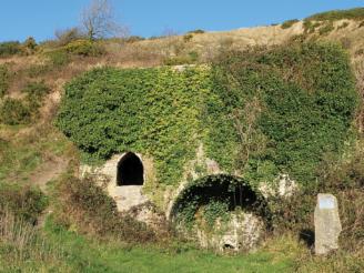 Lime kiln near Church Knowle | The Gorse is controlled by burning and grazing by Longhorn and Ruby Red Devon cattle to prevent it swamping other species. The traditional name for the plant is ‘furze’. In the Bronze Age it was used in smelting furnaces, as it produces high temperatures when burnt but leaves little ash, and later as a fuel in lime kilns, bakers’ ovens and brick-firing; also as fodder for horses and cattle; the flowers in flavouring, scent and medicine; bark in dyeing; stems for walking sticks; and seeds as flea repellent. Even the ash has been put to good use in soap-making and fertiliser. Further along the track is a restored lime kiln. Marl, a mixture of clay and calcium carbonate, was burned in kilns to produce lime for mortar and soil improvement. |
ABOUT THE AUTHOR Retired teacher David Leadbetter has lived in Purbeck most of his life and spent many years exploring the area on foot, researching and recording different aspects of natural history. Since the late 1980s he has been leading guided walks, through different organisations, including a series of his own walks in Purbeck. He has been a regular guide on Brownsea Island and also a volunteer for the Christchurch Countryside Service. He currently volunteers at the Langton Matravers and Purbeck Stone Museum. With his experience and passion for mysteries and local history (in particular the prehistoric period), this is his second book, afterParanormal Purbeck – A Study of the Unexplained. |  |
LINKS
Langton Matravers Local History and Preservation Society, and Purbeck Stone Museum – http://www.langtonia.org.uk/
Priest’s Way – http://www.priestsway.co.uk/
Swanage Railway – http://www.swanagerailwaytrust.org.uk/
Corfe Castle Town Trust – http://www.corfecastletowntrust.co.uk/the-museum/
Tyneham – http://www.isleofpurbeck.com/tyneham.html
Clavell Tower – http://www.landmarktrust.org.uk/search-and-book/properties/clavell-tower-6222
Purbeck Marine Wildlife Reserve and Fine Foundation Marine Centre – http://www.dorsetwildlifetrust.org.uk/reserve_information.html
Studland – http://www.nationaltrust.org.uk/studland-beach/
Dorset County Museum – http://www.dorsetcountymuseum.org/
ORDERING
Please CLICK HERE for ordering options.