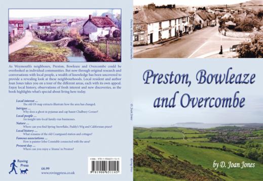
 | BOOK DETAILS Title: Preston, Bowleaze and Overcombe Author: D. Joan Jones RRP: £6.99 Sale Price: £3.99 Publication date: Nov 2012 Format: 212 x 152 mm Number of pages: 80 Illustations: 63 Maps: 6 ISBN: 9781906651-145 PLEASE CLICK HERE FOR ORDERING OPTIONS |
As Weymouth’s neighbours, Preston, Bowleaze and Overcombe could be overlooked as individual communities. But now through original research and conversations with local people, a wealth of knowledge has been uncovered to provide a revealing look at these neighbourhoods. Local resident and author Joan Jones takes you on a tour of the different areas, each with its own appeal. Enjoy local history, observations of fresh interest and new discoveries, as the book highlights what’s special about living here today.
Local interest … The old OS map extracts illustrate how the area has changed.
Intrigue … Why does a ghost in pyjamas and cap haunt Chalbury Corner?
Local people … An insight into local family-run businesses.
Nature … Where can you find Spring Snowflake, Paddy’s Wig and Californian pines?
Local history … What remains of the old Coastguard station and cottages?
Famous associations … How is painter John Constable connected with the area?
Present day … Where can you enjoy a ‘drama’ in Preston?
INTRODUCTION
The book is divided into sections covering the areas of Preston, Overcombe, Bowleaze Coveway, Chalbury Corner, Seven Acres, Telford Recreation Park, Littlemoor Road, Coombe Valley, Wyke Oliver Road and Lodmoor. The text starts with St Andrew’s Church and the origins of Preston. Then imagine setting out on a long-distance walk which has been divided into stretches, in between which a rest is taken with an opportunity to look around and consider other things. So, leaving Weymouth on the A353, one way leads along Preston Beach Road to Overcombe Corner. Here, the road forks right, continuing uphill and along Bowleaze Coveway. Another chapter requires a return to Overcombe Corner where the A353 continues along Preston Road to the roundabout at Chalbury Corner. From here we continue along Preston Road to Seven Acres Road, with a brief diversion to Telford Recreation Park. A further route runs up to Littlemoor. There is also a winding country road up Coombe Valley. This leaves Wyke Oliver Road to be explored, followed finally by a walk around Lodmoor Nature Reserve.
Attention has been focused on both adults and children, including those born in Preston and ‘incomers’. It is hoped that the reader will find not only memories here, but also events and observations of fresh and unexpected interest.
Enjoy your walk!
WHAT REVIEWERS AND INTERVIEWERS HAVE SAID
‘This neat and attractive book is a mix of original research, memories of local people and photographs and maps, old and new, drawn together by local resident and author Joan Jones. ... This attractive coastal area is worth a studied visit; it will be enhanced by carrying a copy of this interesting book.’
Somerset and Dorset Family History Society
CONTENTS
Old area map
Introduction
1 The Origins of Preston: An Ancient Church
St Andrew’s Church
Churchyard flowers and yew trees
The Four Margarets
The Church Rooms
Bell ringing
2 Preston Street
The Rectory to the River Jordan
Some statistics
3 Toll Gate to Overcombe Corner
4 Bowleaze Coveway
Geology
Jordan Hill
Preston’s nonagenarian
5 Overcombe to Chalbury Corner
6 Chalbury Corner to Seven Acres
7 Telford Recreation Park
Preston footballers
8 Littlemoor Road
Westfield Arts College
9 Coombe Valley
10 Wyke Oliver Road
11 Lodmoor
12 Round and About Preston
Local weather
Police matters
The Ridgeway
The Register
Night School
St Andrew’s School
Exploring on foot
And finally
EXTRACT FROM THE BOOK
Today, the word Preston on a road sign along Preston Beach Road (the A353) clearly delineates the boundary line between itself and Weymouth. This road was once, around the 18th century, a turnpike road with a toll gate house near Lodmoor at which a toll or fee had to be paid by all who used it. A toll was a tax or duty paid by users of the road towards its maintenance, and constituted a major improvement in the condition of the country’s roads since Roman times.
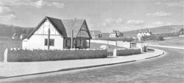
Long after the toll system was dispensed with, the toll house remained, the last occupants being the Shorey family who also ran a horse-drawn cab service. An old milestone along the way indicated the distance to Weymouth as 1 mile and to Wareham as 17 miles. In 1965 the café at Overcombe Corner, on the left-hand side of the road going towards Preston, was demolished and replaced with a block of flats that overlook the bay and Lodmoor. About the same time the petrol station opposite was replaced with a hexagonal toilet block, and the road divided, turning left for Chalbury Corner and right for Bowleaze Coveway which was once the old route to Osmington.
Overcombe Corner Cafe and Petrol Station
 |  |
A sea wall ran from the start of Preston Beach Road opposite Lodmoor to Overcombe Corner, combe being a short valley running up from the coast. This wall was built to separate the shingle beach from the road but was frequently breached in winter’s strong and sometimes violent moods, especially at high tide. This caused intense problems including diversions via Littlemoor into Weymouth and vice versa, plus the cost of repairs and removal of debris and damaged vehicles.
| … Originally, wooden seats were arranged along the esplanade with memorial plaques to lost loved-ones placed above. Due to wear and weathering, several of these much appreciated seats have been replaced with those of more durable limestone. Although the new seats have no back rest, the slabs, which have been cut from Portland Roach limestone, provide seating that will stimulate interest in the wide variety of small fossils found along the Jurassic Coast, including one group of specimens known as Portland Screws. | 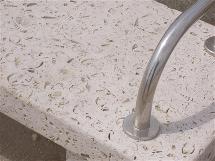 |
… In 1930, a housing development was proposed on Jordan Hill by Weymouth Bay Estate Co. In 1933, plots with a 55-ft frontage and 200-ft depth were offered for sale but only a few were pur chased. The estate was planned to spread from Overcombe Cliffs across the hill to Littlemoor Road, east to the River Jordan and west towards Weymouth. It was to include a sports ground off Littlemoor Road, a recreation ground for Weymouth Cricket Club, a sports field along the banks of the River Jordan and ornamental gardens in Bowleaze Cove. A few plots were sold but a local action group rose to challenge this proposed unwanted development. Door-to-door visits gathered sufficient money to obtain the advice of an eminent barrister and when the council, through a local survey, estimated the total cost to build such an estate as too expensive, the plan was finally discarded.
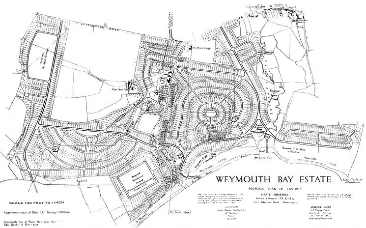
Caption: Weymouth Bay Estate proposed plan of layout, showing 1333 plots.
ORDERING
Please CLICK HERE for ordering options.